Forest Health Pilot
Vegetation Monitoring Protocol for Effectiveness (trend):
forest health, wildlife habitat, fuels
Prepared by:
Jo Ann Fites
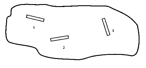
Figure 1. Layout of 3 Monitoring Strip Plots within "Stand".
Forest Health Pilot - Permanent Vegetation Monitoring Plot Layout
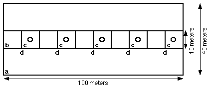
Figure 2. Layout of each monitoring strip plot
a - 40 x 100 meters (0.4 hectare) all live trees & snags > 76 centimeters dbh and > 3 meters tall (snags), photo fuel model.
b - 10 x 100 meters (0.1 hectare) all live trees 40 - 76 cm, snages > 12 centimeters dbh and > 3 meters tall.
c - 5 10 x 10 meters (0.05 hectare) trees 13 - 40 centimeters dbh, saplings, saprophytic plants.
d - 5 10 meters line intercept cover of deciduous shrubs, evergreen shrubs, all vegetation < 0.5 meter, all vegetation 0.5-2 meters tall.
o - average of four sherical densiometer readings of canopy cover in each cardinal direction.For live trees, only dbh and species is recorded. For snages decay clsss and species aer recorded.
Table 1. Description of "ecological group" characteristics.
| Type | Ecological "Zone" | Species Composition | Aspect, Topographic Position, Slope | Elevation | Soil Depth |
| Mixed Conifer - "moist" | westside | Douglas-fir, white fir, ponderosa pine, sugar pine, incense cedar | N&E | <5,000 feet | >20 in. |
| Mixed Conifer - "dry" | weswde | Same as above, but may not have much Doulas-fir or white fir | S,W & ridges | <5,000 feet | >20 in. |
| White fir - Mixed Conifer - "moist" | westside | Dominantly white fir (usually >70%) with some incense cedar, sugar pine, ponderosa pine or Jeffrey pine. Up to 10% red fir may occur. | N&E | >5,000 feet | >20 in. |
| White Fir - Mixed Conifer - "dry" | westside | Same as above, but with more pine likely. Up to 10% red fir may occur. | S,W & ridges | >5,000 feet | >20 in. |
| Mixed Conifer - "moist" | transition | Jeffrey pine, ponderosa pine, white fir, with some Douglas-fir, white fir or sugar pine, often present, but not always. | N&E | <5,000 feet | all |
| Mixed Conifer - "dry" | transition | Jeffrey pine, ponderosa pine with some white fir, Douglas-fir, incense cedar or sugar pine. The latter 4 species may not always be present. | S,W & ridges | <5,000 feet | all |
| White Fir | transition & eastside | dominantly white fir (>70%), scattered pines may occur. | all, but primarily N & E | >5,000 feet | all |
| Yellow Pine - flats | transition & eastside | Dominantly ponderosa and Jeffrey pine, with sagebrush and bitterbrush understory | all aspects, bottoms with slopes < 15% | all | all |
| Eastside Pine- "moist" | eastside | Yellow pines and some white fir perhaps but not necessarily | N & E aspects | all except where overlaps with whit fir type | all |
| Eastside Pine- "moist" | eastside | Yellow pines primarily | S & W aspects & ridges | all | all |
| Red fir | all | Red fir dominates or co-dominates (>20%) with white fir, Jeffrey pine, western white pine, mountain hemlock or lodgepole pine | all | all where it occurs | all |
| Lodgepole pine | all | Dominantly lodgepole pine (>70%) with some white fir, red fir or other species | primarily lower slope positions around wet areas or cold air drainages | all where it occurs | all |
VEGETATION MONITORING
DESCRIPTION AND SPECIFICATIONS
C.7 Random Plot Location Establishment- Three strip plots will be used to sample each sample unit. The starting position along the unit access road or trail, (or if not present a random point along the perimeter), and the direction of the first strip plot will be randomly determined prior to entering the unit...The direction of subsequent strips will be randomly determined while in the unit. All boundaries of the strips will be at least 25 meters from the edge of the unit. All boundaries will be at least 50 meters from major roads, unless the sample unit is a linear defensible fuel profile zone (DFPZ) that does not contain suitable area at this distance from roads. For samples in DFPZ, the strips will be at least 5 meters from major roads. Skid roads and trails caused by management activities are not avoided when locating plots. In large units (>10 acres), plots will be spaced at intervals of 150 meters sor more. In smaller units (<10 acres), spacing may drop to 75 meters, but it is preferred that whenever possible, strips are at least 100 meters from any other strip located within the unit. From the first strip plot, the second plot is selected by choosing a random bearing and then traversing along the bearing for 150 meters (or if it is a small unit 75 meters) from the end of the first plot to the start of the second. When the random bearing results in selection of a site that exceeds the area of the plot and distance from edge of unit or road requirements listed above, then another random bearing is selected. The third plot location is determined from a random bearing and proceeding from the second plot.
The distance between plots is horizontal distance.
C.8 The Strip Plot
The strip plot for this Contract will consist of:
1) 0.4 hectares (100 x 40 m) rectangular, fixed area plot for large (>76 centimeters dbh) live trees and snags (-Large Tree Plot/LTP);
2) a 0.1 hectares (100 x 10 m) rectangular, fixed area plot for live trees 40-76 centimeters dbh and snags > 12 centimeters dbh (-Medium Tree Plot/MTP);
3) Five 0.05 hectares (10 x 10 m) subplots for trees 13-40 centimeters dbh, all saplings < 13 centimeters dbh and > 2m height, and saprophytic plant species (i.e., Allotropa, Cephalanthera, Corallorhiza, Pleuricospora, Pterospora, and Sarcodes) (-Small Tree Plot/STP);
4) Five 10 meter line intercept transects along the border of each 0.05 hectare subplot for deciduous and evergreen shrub cover, total vegetation cover <0.5 meters and 0.5-2 meters tall (-Line Intercept Plot/LIP); and
5) overstory canopy cover at the center of each of the five 0.05 hectares plots with the average of spherical densiometer measurements taken in four cardinal directions (-LIP).
The stands and numbers of plots are listed in Exhibit 1, Inventory List.
Examples of all the subplots required to complete one strip plot are shown in Figures 1 and 2.
C.9 Reference Point Establishment.
Establish a reference point (RP) for each stand sampled. The RP will be an identifiable feature on the ground and on the appropriate aerial photograph. Identify the ground RP by tying two - 3 ft lengths of yellow flagging on a tree or shrub. Write on the flagging, in waterproof ink, the stand number and the distance (in meters) and azimuth to the selected point.
Document the RP, distance, and azimuth from the RP to the corner of one of the strip plots in the stand, on the Site Reference Info. Sheet (Exhibit 2).
C.10 Plot Location Establishment.
The location of the second and later strip plots can be established at the randomly determined bearings and preset distances below by pacing and compass if the Contractor is able to meet the tolerance limits for distance and azimuth. The tolerance for azimuth is + 3 degrees, and + 10% for distance.
The Contractor shall mark, on the ground, the northwest corner of each strip plot with a piece of 10" long 1/2" rebar, painted yellow on the top. Each corner of the strip plot and subplots shall be flagged with 2 three foot lengths of yellow flagging on a shrub or tree, preferably at a height of 5 feet from the ground. One of the flags shall be labeled with the stand number, strip plot number and subplot number (for the latter as appropriate) with permanent, waterproof black ink.
Use the following procedure to locate the strip plot if a plot falls on, or within 50 meters (or 5 meters when the stand is to be treated as a DFPZ), of an improved (4x2 or well used 4x4) road. Old overgrown logging roads and skid trails are not "improved" roads.
1. Proceed on the same azimuth 300 meters; if not feasible, return to the original point on the road, then:
2. Proceed 150 meters, 90 degrees to the right of the survey line; if not feasible, return to the point on the road, then:
3. Proceed 150 meters, 90 degrees to the left of the survey line; if not feasible, return to the point on the road, then:
4. Proceed 150 meters on a back azimuth.
The strip plot is then established and measured. After measurement, return to the plot on the road and continue to the next plot.
C.11 Survey Technique
The survey technique may be hand compass (adjusted to local declination: 17 1/2 degrees east) and pacing, or an equivalent method to locate points within the tolerance limits listed in Exhibit 9.
C.12 Site Reference Info. Card (R5-1900-1)(Exhibit 2)
This form (or negotiated substitute using a field data recorder) will be filled out for each stand, and includes the following stand features:
A. - The Stand Number (- Unit ID No.) shall be recorded (See Exhibit 1).
B. - The Date shall be recorded.
C. - Reference Point (RP) - Information shall include tree species and distance and azimuth from the RP to one of the plots within the stand. Record distance in meters. Information regarding reference point establishment can be found in Section C.9 of this contract.
D. - Sketch - The following stand features shall be mapped by the Contractor: The reference point, distance and azimuth to a strip plot from the RP, the shape of the stand, and the location of the strip plots including plot location, plot numbers, and distances and azimuths between plots. Also, the Contractor shall record the following topographic features encountered along the survey lines: Roads (improved and unimproved), trails (hiking, jeep, etc.), creeks, drainages, ridges, springs, meadows, lakes, and rocky areas. The Contractor will not be responsible for recording any topographic feature that is not plainly viewed from the strip plots or lines between strip plots.
C.13 General Requirements for Measuring and Recording Information on the Site Reference Information Card (Exhibit 2)
C.13.1 Stand Identification and Location (See Exhibit 5: Section 410 of the Forest Inventory Analysis Users Guide (F.I.A.U.G.))
Field 1. - National Forest - For the purpose of this contract, the following codes shall be used: "11" for the Plumas National Forest, "17" for the Tahoe National Forest, and "06" for the Lassen National Forest.
Field 4. - Plot Number/Project - The plot number is the same as the project number. Project numbers are listed under Item and Compartment Numbers in Exhibit 1. The Contractor will fill in the four digit code.
Field 5.- District - For the purpose of this contract the following codes shall be used: 51- Almanor Ranger District, Beckworth District, 53 - Hat Creek District, 58 - Eagle Lake District, 56 - Mt. Hough District, 56 - Sierraville District, 54 - Feather River District.
Field 7. - Stand No. - The stand number equals the Unit ID number.
Field 8. - Date - The month and year of the exam shall be recorded by the Contractor. Refer to section 410, field 8 in the F.I.A.U.G. for proper recording technique (Exhibit 5).
Field 12 - Aspect See Section 410, field 12 of the F.I.A.U.G. for details.
Field 13 - Slope See Section 410, field 13 of the F.I.A.U.G. for details.
Field 16 - History Code - Record the 1 digit code which best describes the stand history. This code identifies stand history as it relates to previous management activities or wildfires in the stand:
Code Explanation 1 No evidence of management or wildfire 2 Management has occurred on the site within the last 20 years 3 Management activity occurred on the site more than 20 years ago 4 There is evidence of wildfire within the last 20 years 5 There is evidence of wildfire and management within the last 20 years.
The Contractor shall record the names of the crew in the Crew/Comments section provided on the Site Reference Information Card.
C.14 General Requirements for Measuring and Recording Information on the Tree Plot Record Form (Exhibit 3)
C.14.1 Strip Plot (SP)
Before measuring and recording data from each SP, the corners of each of the subplots must be measured and flagged.
All trees are determined to be "in" (Tally Trees) by measuring from the center axis of the plot to the center of the tree stem at ground level. When the center of the bole of the tree at the dbh height is within the plot or on the plot boundary, then it is considered "in". The distance along plot boundaries is horizontal distance. Exhibit 7, Borderline Tree Measurements (F.I.A.U.G Sec. 550), shows how to measure limiting distance on the plots.
C.14.2 Sampling Method. The Contractor can determine tally trees in the LTP, MTP, and STP fixed-area plots using a logger's tape or any measuring devise that will accurately measure distances in meters and tenths of meters.
Field 11 - Tree DBH - See Section 420, field 11 of the F.I.A.U.G., and Section 535 (Exhibit 7) for proper tree diameter measurement procedures. Diameters are required for live and dead trees.
C.14.4 Medium Tree Plot (MTP)
All live trees 40 to 76 centimeters dbh, and snags 12 to 76 centimeters dbh (and greater than 3 meters tall) will be tallied that fall within the O.1 hectares (100 x 10 meters) rectangular fixed area plot. Species will be recorded using the two digit codes in section 420, Field 5 of the F.I.A.U.G. Measure dbh in inches to the nearest 0.1 inch, using a dbh tape as described in Section 420 of the F.I.A.U.G. Field 1, record type, is completed as an "F" for live trees and "D" for snags.
C.14.5 Small Tree Plot (STP). All trees 13-40 centimeters dbh will be tallied that fall within the 0.05 hectares (10 x 10 m) subplots. Species will be recorded using the two digit codes in section 420, Field 5 of the F.I.A.U.G. Measure dbh in inches to the nearest 0.1 inch, using a dbh tape as described in Section 420 of the F.I.A.U.G. Field 1, record type, is completed as an "F".
For trees < 13 centimeters dbh and > 2 meters tall, record the number of saplings by species. Field 1, record type, is completed as a 'S". Trees are not tagged and Field 3 is a count of the number of saplings for each species.
For seedlings < 13 centimeters dbh and < 2 meters tall, record the number by species. Field 1 is completed as "X". Seedlings are not tagged and Field 3 is a count of the number of seedlings for each species.
Field 10 "Optional": Subplot Number - The subplot number will be recorded in "optional" Field 10. The numbers entered will start at I for the first 0.05 hectares subplot and proceed to 2, etc., through 5, in consecutive order.
C.14.7 Cover Transects- "Canopy Cover Data' Form (Exhibit 4) The top of this form shall be filled out including the same information as on the Tree Plot Record form, including codes for the National Forest, District, Date, Crew, Plot no./Project, Stand no./Unit ID. The last field, "Plot Number", shall - Field 2 (Point No.) on the Tree Plot Record form.
Field 17 - Line No.-The transacts are numbered the same as the associated subplot.
Fields 18-21 - Along one side of each of the STP plots, a line intercept transect will be placed. Canopy cover of vegetation < 2 tall that crosses the line transect will be recorded to the nearest decimeter. Cover will be recorded separately by physiognomic/size classes represented by the following categories: decidous shrubs (Field 18), evergreen shrubs (Field 19), total vegetation < 0.5 meters tall (Field 20), and total vegetation 0.5 -2 meters tall (Field 21). Cover will be determined for 5 meters segments of each 10 meters line transect, and then summed for recording on the data sheet by 10 meters transect.
Field 22 - Overstory Canopy - Overstory canopy cover will be determined at the center of each 0.05 hectares subplot. Four individual measurements, taken in each of the 4 cardinal directions will be recorded. The spherical densiometer will be held at a height of 4.51.
Field 23 - Saprophytic Plant Tally - The number of saprophytic plant individuals will be tallied within each 0.05 hectares subplot. They will not be tracked by individual species but the following plants will be included in the tally: Allotropa, Cephalanthera, Corallorhiza, Pleuricospora, Pterospora, and Sarcodes. Line drawings of these plants are included in Appendix A.
Field 24 - Fuel Model/Residue - The matching Natural Forest Residue photo number shall be recorded. While performing the monitoring measurements, the Contractor, at each LTP plot, will ocularly view and note the vegetative composition and structure, and the fuel loading. Upon completion of the strip plots, the Contractor shall use these notes to match the existing stand down woody component to the corresponding photograph in the Photo series for Quantifying Natural Forest Residues Guide (Report PSW-56). Only dead and down woody material from trees and shrubs is being inventoried, not the live species in the sample areas.